![](/images/other/stat-length.png)
![Randonnée Marche Le Valtin - BELVEDERE DES 3 LACS (BOUCLE) - Photo](https://media.geolcdn.com/t/1900/400/ext.pjpeg?maxdim=2&url=https%3A%2F%2Fstatic1.geolcdn.com%2Fsiteimages%2Fupload%2Ffiles%2F1553511878bg_sport_marche.png)
BELVEDERE DES 3 LACS (BOUCLE)
surceneux
Utilisateur
![Longueur](/images/other/stat-length.png)
Longueur
8,5 km
![Altitude max](https://static1.geolcdn.com/siteimages/upload/files/1508320355ic_sort_altitude_max_24dp.png)
Altitude max
1302 m
![Dénivelé positif](https://static1.geolcdn.com/siteimages/upload/files/1508320355ic_sort_den_pos_24dp.png)
Dénivelé positif
229 m
![Km-Effort](/images/other/stat-length.png)
Km-Effort
11,5 km
![Altitude min](https://static1.geolcdn.com/siteimages/upload/files/1508320355ic_sort_altitude_min_24dp.png)
Altitude min
1214 m
![Dénivelé négatif](https://static1.geolcdn.com/siteimages/upload/files/1508320355ic_sort_den_neg_24dp.png)
Dénivelé négatif
232 m
![Boucle](https://static1.geolcdn.com/siteimages/upload/files/16400158638029165_repeat_loop_refresh_sync_direction_icon.png)
Boucle
Oui
Date de création :
2020-10-20 13:18:34.062
Dernière modification :
2020-10-20 20:39:12.945
![Marche](https://static1.geolcdn.com/sitytour/trail-icons/101.png)
2h17
Difficulté : Facile
![Scannez ce code QR pour ouvrir la randonnée dans l'application SityTrail](https://capi.geolives.com/qq0zvz2zws4bq2lad0pu/sitytour/trails/2583258/qr.png?size=200)
Application GPS de randonnée GRATUITE
À propos
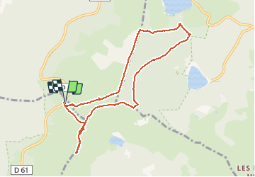
Randonnée Marche de 8,5 km à découvrir à Grand Est, Vosges, Le Valtin. Cette randonnée est proposée par surceneux.
Description
GAZON DU FAING AUBERGE SOULTZERER ECK TAUBENKLANGFELSEN LAC DES TRUITES LAC NOIR BELMONT LAC BLANC HTES CHAUMES GAZON DU FAING
Localisation
Pays :
France
Région :
Grand Est
Département/Province :
Vosges
Commune :
Le Valtin
Localité :
Unknown
Départ:(Dec)
Départ:(UTM)
355952 ; 5330208 (32U) N.
Commentaires
Randonnées à proximité
![Randonnée Marche Le Valtin - Les Rochers des Hirschsteine - Lac Vert - Photo](https://media.geolcdn.com/t/375/260/4177d9e5-d8bc-4dac-ac45-c42f01ca30d3.jpg&format=jpg&maxdim=2)
![Marche Marche](https://static1.geolcdn.com/sitytour/trail-icons/101.png)
Les Rochers des Hirschsteine - Lac Vert
Marche
Difficile
(2)
Le Valtin,
Grand Est,
Vosges,
France
![](/images/other/stat-length.png)
14,4 km | 22 km-effort
5h 2min
![](https://static1.geolcdn.com/siteimages/upload/files/16400158638029165_repeat_loop_refresh_sync_direction_icon.png)
Oui
![Randonnée Randonnée équestre Orbey - 2020-06-28 WE Orbey Petit Hohnack Glasborn - Photo](https://media.geolcdn.com/t/375/260/ef012c2d-591e-4a7a-ae45-376661550d14.jpg&format=jpg&maxdim=2)
![Randonnée équestre Randonnée équestre](https://static1.geolcdn.com/sitytour/trail-icons/301.png)
2020-06-28 WE Orbey Petit Hohnack Glasborn
Randonnée équestre
Difficile
(1)
Orbey,
Grand Est,
Haut-Rhin,
France
![](/images/other/stat-length.png)
22 km | 31 km-effort
4h 5min
![](https://static1.geolcdn.com/siteimages/upload/files/16400158638029165_repeat_loop_refresh_sync_direction_icon.png)
Oui
![Randonnée Randonnée équestre Orbey - 2020-06-27 WE Orbey Noir Gazon Vert Forlet - Photo](https://media.geolcdn.com/t/375/260/f691f0a3-eb26-4898-acd3-19530bfd0b6d.jpg&format=jpg&maxdim=2)
![Randonnée équestre Randonnée équestre](https://static1.geolcdn.com/sitytour/trail-icons/301.png)
2020-06-27 WE Orbey Noir Gazon Vert Forlet
Randonnée équestre
Moyen
(1)
Orbey,
Grand Est,
Haut-Rhin,
France
![](/images/other/stat-length.png)
21 km | 30 km-effort
3h 59min
![](https://static1.geolcdn.com/siteimages/upload/files/16400158638029165_repeat_loop_refresh_sync_direction_icon.png)
Oui
![Randonnée Marche Le Valtin - Col de la Schlucht - Photo](https://media.geolcdn.com/t/375/260/5b598871-c43c-4378-92fe-f06bddb4af29.jpg&format=jpg&maxdim=2)
![Marche Marche](https://static1.geolcdn.com/sitytour/trail-icons/101.png)
Col de la Schlucht
Marche
Très facile
(1)
Le Valtin,
Grand Est,
Vosges,
France
![](/images/other/stat-length.png)
3,5 km | 5,2 km-effort
1h 17min
![](https://static1.geolcdn.com/siteimages/upload/files/16400158638029165_repeat_loop_refresh_sync_direction_icon.png)
Oui
![Randonnée Marche Le Valtin - Le Sentier des Roches - Photo](https://media.geolcdn.com/t/375/260/f2737479-0e9e-43ec-9b66-c9706dc8ef91.jpg&format=jpg&maxdim=2)
![Marche Marche](https://static1.geolcdn.com/sitytour/trail-icons/101.png)
Le Sentier des Roches
Marche
Difficile
(2)
Le Valtin,
Grand Est,
Vosges,
France
![](/images/other/stat-length.png)
20 km | 34 km-effort
7h 43min
![](https://static1.geolcdn.com/siteimages/upload/files/16400158638029165_repeat_loop_refresh_sync_direction_icon.png)
Oui
![Randonnée Marche Stosswihr - Tour du belvedere avec le passage sur les crêtes - Photo](https://media.geolcdn.com/t/375/260/5b3c85c1-2643-45e9-9769-80e100e05dda.jpg&format=jpg&maxdim=2)
![Marche Marche](https://static1.geolcdn.com/sitytour/trail-icons/101.png)
Tour du belvedere avec le passage sur les crêtes
Marche
Très facile
(3)
Stosswihr,
Grand Est,
Haut-Rhin,
France
![](/images/other/stat-length.png)
8,5 km | 0 m-effort
2h 28min
![](https://static1.geolcdn.com/siteimages/upload/files/16400158638029165_repeat_loop_refresh_sync_direction_icon.png)
Oui
![Randonnée Autre activité Soultzeren - Totom 4 lacs - Photo](https://media.geolcdn.com/t/375/260/ext.jpg?maxdim=2&url=https%3A%2F%2Fservices.sitytrail.com%2FGeolivesWS%2FDownloadMedia.ashx%3FTrailID%3D789048%26Media%3D20170713134427.jpg)
![Autre activité Autre activité](https://static1.geolcdn.com/sitytour/trail-icons/900.png)
Totom 4 lacs
Autre activité
Moyen
(1)
Soultzeren,
Grand Est,
Haut-Rhin,
France
![](/images/other/stat-length.png)
15,6 km | 26 km-effort
4h 37min
![](https://static1.geolcdn.com/siteimages/upload/files/16400158638029165_repeat_loop_refresh_sync_direction_icon.png)
Oui
![Randonnée Marche Hohrod - Circuit historique 1914-18 Hohrodberg - Linge - Photo](https://media.geolcdn.com/t/375/260/ext.jpg?maxdim=2&url=https%3A%2F%2Fservices.sitytrail.com%2FGeolivesWS%2FDownloadMedia.ashx%3FTrailID%3D313116%26Media%3Dfix__20140615152326.jpg)
![Marche Marche](https://static1.geolcdn.com/sitytour/trail-icons/101.png)
Circuit historique 1914-18 Hohrodberg - Linge
Marche
Moyen
(1)
Hohrod,
Grand Est,
Haut-Rhin,
France
![](/images/other/stat-length.png)
14 km | 19,8 km-effort
5h 50min
![](https://static1.geolcdn.com/siteimages/upload/files/16400158638029165_repeat_loop_refresh_sync_direction_icon.png)
Oui
![Randonnée Marche Le Valtin - Les Hirschsteine - Photo](https://media.geolcdn.com/t/375/260/ext.jpg?maxdim=2&url=https%3A%2F%2Fservices.sitytrail.com%2FGeolivesWS%2FDownloadMedia.ashx%3FTrailID%3D311037%26Media%3Dfix__20140608114301.jpg)
![Marche Marche](https://static1.geolcdn.com/sitytour/trail-icons/101.png)
Les Hirschsteine
Marche
Difficile
(1)
Le Valtin,
Grand Est,
Vosges,
France
![](/images/other/stat-length.png)
16,1 km | 25 km-effort
6h 28min
![](https://static1.geolcdn.com/siteimages/upload/files/16400158638029165_repeat_loop_refresh_sync_direction_icon.png)
Oui